
INDIANAPOLIS, IND. — A calmer weather pattern will likely close out September across the Ag Belt, with BAM Weather anticipating 4 to 5 day dry stretches for the eastern Ag Belt roughly between September 21 and 27, as an absence of strong systems and cold fronts allows a more settled pattern to take hold heading into the final week of the month.
A Calmer Pattern Closes Out September for the Ag Belt
According to BAM Weather’s latest long-range outlook, the period from roughly the 21st through the 27th of September is the window forecasters are specifically watching for extended dry gaps across the Ag Belt. That timing follows what forecasters describe as a front expected around the 21st or 22nd, after which an absence of additional systems and cold fronts should allow a calmer, more settled pattern to develop.
For a growing season that has seen its share of active, disruptive weather in recent weeks, this anticipated shift toward calmer conditions represents a notable change in the broader pattern as September draws to a close.
4 to 5 Day Dry Stretches Anticipated for the Eastern Ag Belt
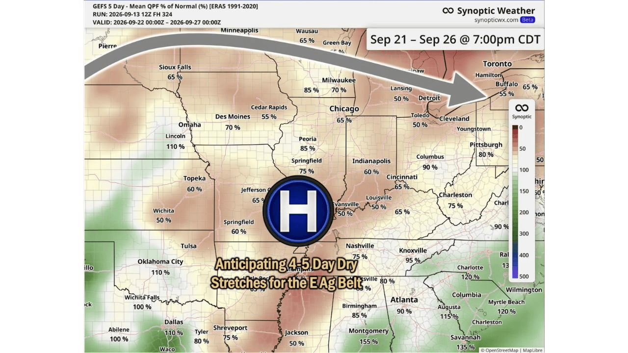
The core of this outlook centers on the eastern Ag Belt, where BAM Weather is specifically anticipating 4 to 5 day dry stretches to develop following the front expected around September 21 or 22. That kind of extended dry window, driven by a building area of high pressure centered over the Ohio Valley and Midwest, would offer producers across this region a meaningful stretch of consistent, workable conditions right as harvest continues to ramp up.
A multi-day dry window like this one carries real practical value, since it gives producers enough consecutive days to plan fieldwork around rather than working around isolated, unpredictable gaps between rounds of rain.
Where the Driest Conditions Are Expected
Rainfall percentage of normal projections for the September 21 through 26 window show notably low totals across much of the eastern Ag Belt, with Louisville and Evansville both projected at just 50 percent of normal, and Detroit and Cleveland also trending around 50 percent. Indianapolis is projected around 60 percent of normal, with Cincinnati close behind at 65 percent and Chicago also around 65 percent.
Farther west, Des Moines is projected at 70 percent of normal while Sioux Falls, Omahaand Cedar Rapids all trend in the 55 to 65 percent range, suggesting the drier signal extends well beyond just the immediate Ohio Valley core into a broader stretch of the Midwest.
The South and Southeast Trend Wetter During the Same Window
Not every part of the country shares in this drier outlook. The South and Southeast show a notably different signal for the same window, with Savannah projected at 135 percent of normal, Columbia at 120 percent, and both Dallas and Oklahoma City trending around 110 percent. That contrast between a drying Midwest and Ohio Valley and a wetter South and Southeast reflects the broader pattern shift forecasters are tracking as September closes out.
Producers in these wetter-trending regions should not expect the same kind of extended dry window forecasters are highlighting for the eastern Ag Belt during this same late-September period.
Why This Matters as Harvest Season Continues
With harvest season fully underway across much of the Ag Belt, a reliable 4 to 5 day dry stretch carries significant value for producers trying to time fieldwork, grain drying and equipment logistics around the weather. Rather than working around a patchwork of short, unpredictable dry windows, an extended stretch like the one now being anticipated for late September would give producers a clearer runway to make meaningful harvest progress.
That kind of forecast confidence, built around the expected absence of additional fronts and systems after the 21st or 22nd, offers a useful planning tool for anyone trying to map out harvest logistics over the final stretch of the month.
What Comes Before the Dry Stretch
Before this anticipated calmer period arrives, BAM Weather notes that a front is still expected to move through around September 21 or 22, meaning the eastern Ag Belt will likely see one more round of unsettled weather before conditions transition toward the extended dry window now being highlighted. Producers should plan around that front first, before shifting their attention to the multi-day dry stretch forecasters currently anticipate to follow behind it as September draws to a close.


