
DES MOINES, IOWA — Significant flash flooding is likely across central Iowa today, with Max Velocity Weather warning that Des Moines and locations south of Interstate 80could see repeated downpours dropping 3 to 5 inches of rain overnight, with isolated totals approaching 6 inches, as a powerful surge of low-level winds ignites a widespread cluster of heavy thunderstorms this evening.
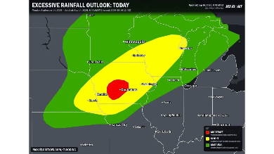
Moderate Risk Places Des Moines at the Center of Tonight’s Threat
Today’s excessive rainfall outlook places Des Moines under a Moderate Risk, the second-highest category on the scale, reflecting forecasters’ expectation that numerous flash floods are likely within this specific zone. That designation represents a significant escalation from the more typical Slight and Marginal categories seen in most day-to-day flooding outlooks, underscoring just how serious today’s threat has become for the Des Moines area specifically.
Surrounding Des Moines, a broader Slight Risk zone extends from near Sioux Fallsthrough Omaha, Lincoln and Cedar Rapids, with an even wider Marginal Risk stretching toward Fargo, Minneapolis, Milwaukee and Chicago.
A Surge of Low-Level Winds Ignites Widespread Storms This Evening
While scattered storms will bring some heavy rain to the region this afternoon, forecasters say the primary danger arrives this evening, when a powerful surge of low-level winds is expected to ignite a widespread cluster of heavy thunderstorms. That evening timing means the most dangerous phase of today’s weather will unfold well after the afternoon’s initial round of activity, catching some residents off guard if they assume the worst has already passed.
Communities across central Iowa should treat this evening, rather than the afternoon, as the period requiring the most caution as today’s setup continues to evolve.
3 to 5 Inches of Rain Possible Overnight, With Isolated Totals Near 6
The heaviest rainfall is squarely targeting Des Moines and areas south of Interstate 80, where forecasters expect repeated downpours to drop 3 to 5 inches of rain overnight, with isolated spots potentially approaching 6 inches. That kind of total, especially when it accumulates overnight while many residents are asleep, represents a serious flooding threat capable of affecting roads, basements and low-lying property across the Des Moines metro.
Residents across this corridor should prepare now for the possibility of significant overnight flooding, rather than waiting until conditions have already deteriorated to take precautions.
Training Storms Raise the Risk for Rapidly Rising Water
Forecasters specifically warn that tonight’s intense storms will continuously rebuild and track over the exact same areas after dark, a pattern known as training that dramatically increases the risk for rapidly rising water in urban areas and at low-water crossings. Because training storms repeatedly dump heavy rain over the same relatively narrow corridor rather than spreading it out, they are capable of producing the kind of extreme, localized totals now being forecast for the Des Moines area.
With the risk for rapidly rising water described as extremely high, residents across central Iowa, particularly around Des Moines and south of Interstate 80, should avoid driving through low-water crossings tonight and stay alert for flash flood warnings as this dangerous setup continues to unfold through the overnight hours.


